Museum Detectives, Part 2: The Plot Thickens
How do we unravel the mysteries that we find in our archives? NERHS Director/Curator gives a crash course in museum detective work (Part 2). You can read Part 1 of this series here.
The investigation continues.
When I, your loyal Museum Detective last left you, I was thinking about my visual and emotional reactions to a series of three photographs from NEF’s extensive archival collection. I was ready to embark on a real search to find out more. I set out to discover where and when the photos were taken, and what was going on in the pictures.
Casting a Wider Net
I started by asking myself about my own impressions of the photos. Questions like “what do I see?” and “how does this make me feel?” are a great start, but at a certain point you have to expand your search. This means taking a closer look, compiling your resources, and maybe even bringing in some outside help.
What Do We Already Know? Quite a lot, in fact. We know that Near East Relief’s presence in Asia Minor was very well-established by 1921. A quick review of one of our earliest archival maps (at left) shows more than 140 Near East Relief orphanages and dozens of other resources, including hospitals and refugee camps, scattered throughout Turkey and the adjoining countries. Near East Relief worked in many coastal communities. There were relief centers in Constantinople, Samsoun, Trebizond, Batum, and Beirut. We also know that Near East Relief assisted refugees following the burning of Smyrna. Near East Relief was also active in the subsequent population exchange between Turkey and Greece.
Who Can We Talk To? The NEF archives are located at the Rockefeller Archive Center in Tarrytown, NY. Previously, the collection resided at the NEF office in Manhattan. The collection has not been processed, meaning that the contents are in the same condition that they were in when the materials were donated. They have not yet been arranged by date or theme. The knowledgeable archivists can point me towards other boxes in the collection that may be related to a certain photo, but even they cannot know exactly what is in every single box. Sometimes documents and photographs turn up in unexpected places.
A former NEF staff member from the early 2000s remembers putting the photographs into sleeves and binders. Before that, the loose photos were in unlabeled cardboard boxes in the office. Any accompanying written information (if it ever existed) was probably lost many years ago. Luckily, I have plenty of contacts who know a great deal about this subject matter. I fire off a few emails, including one to a friend who grew up in Turkey, and another to a Levantine historical website.
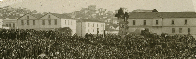
A third photo from the NEF archives gives us more information.
What Details Stand Out? As we discussed before, some characteristics are cues for a certain location. It may be as obvious as a well-known architectural feature, or as subtle as a garment that was worn at a particular orphanage. It also helps to look at companion photographs. Even if you do not know the original location, a different view of the same setting can reveal new details.
A third photograph (above) gives us even more information. It is clearly the same scene. We see many of the same components: a crowd on the shore, boats in the water, and some white buildings. But this shot reveals more of the landscape. The city rises away from the water on a large hill at the far right. I can make out a tooth-like pattern that reminds me of castle wall on top of the hill — perhaps a fortress? A distinctive aqueduct cuts across the background. A spire rises sharply into the sky behind a white building on the far left. One of the boats is flying a striped flag.
I now have a solid working hypothesis: I think that these are photographs of refugees on the quay at Smyrna in the wake of the fires.
To the Library (and the Internet)!
We know that there was a dramatic refugee crisis in Smyrna after the September 1922 fires. How do these photos match up to images of early twentieth-century Smyrna?
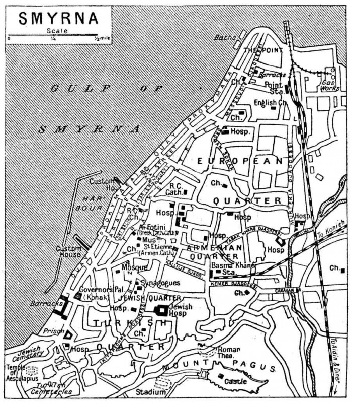
A quick online search turns up dozens of photographs and souvenir postcards of Smyrna. Of course, as we search for photos we should keep in mind that the fires destroyed many buildings and drastically changed the appearance of Smyrna’s waterfront. A trip to the nearest public library yields a few terrific books on Smyrna, and some helpful maps showing the different areas of the city.
Using a similar map to this one (left), I find some more support for my Smyrna hypothesis. The hill with the tooth-like pattern could be Mount Pagus, which boasted a castle by the same name; both are now called Kadifekale. The aqueduct near the hill resembles old photographs of the Kizilcullu aqueduct in the Smyrna suburb once known as Paradise. Could a photographer standing on a boat in the Gulf of Smyrna capture the waterfront, a fortress, and an aqueduct from that vantage point?
It certainly seems like it could be Smyrna…but is it? Or is a new email about to turn my Smyrna theory on its head?
Signing off for now,
Molly Sullivan
Museum Detective
(and NERHS Director/Curator)
What’s next for our intrepid Museum Detective? Check back soon for Part 3 of this story!

Postcards of Smyrna from the Armenian Genocide Museum-Institute